


How do you identify the different Amsterdam canal rings?
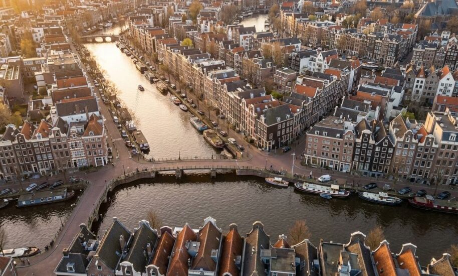
Amsterdam’s canal rings are four concentric waterways – Singel, Herengracht, Keizersgracht, and Prinsengracht – that form the city’s UNESCO World Heritage canal belt. You can identify each ring by its distinctive architecture, building heights, and unique landmarks. Each canal has specific characteristics that make it recognisable once you know what to look for during your Amsterdam tours.
What are Amsterdam’s canal rings and why do they matter?
Amsterdam’s canal rings are four concentric waterways that create the famous horseshoe-shaped canal belt around the historic city centre. The Singel forms the innermost ring, followed by Herengracht, Keizersgracht, and Prinsengracht as the outermost ring. This 17th-century canal system earned UNESCO World Heritage status in 2010 for its outstanding universal value.
The canal rings matter because they represent one of the world’s most successful examples of urban planning from the Dutch Golden Age. Built between 1613 and 1665, this system transformed Amsterdam into a major commercial hub while creating the distinctive cityscape that defines Amsterdam attractions today.
Each ring served different purposes in the city’s social and economic structure. The Herengracht housed wealthy merchants, the Keizersgracht accommodated successful traders, and the Prinsengracht provided space for warehouses and workshops. The Singel, originally a defensive moat, became the boundary between the old medieval city and the new expansion.
Understanding these rings helps you navigate Amsterdam more effectively and appreciate the city’s remarkable urban design. Whether you’re exploring on foot or by boat, recognising the canal rings adds depth to your Amsterdam itinerary and helps you understand the historical significance of what you’re seeing.
How can you tell the difference between each canal ring?
You can identify Amsterdam’s canal rings by observing architectural styles, building heights, and distinctive landmarks. Each ring has unique characteristics that become apparent once you know what to look for during your exploration of Amsterdam activities.
The Singel features narrow medieval buildings mixed with later additions. You’ll spot the floating flower market (Bloemenmarkt), the distinctive round Lutheran church, and generally smaller-scale architecture. The buildings here often appear more cramped and irregular compared to the outer rings.
The Herengracht displays the grandest architecture, with wide, symmetrical canal houses reaching four to five storeys. Look for elaborate gables, large windows, and the famous Golden Bend section between Leidsestraat and Vijzelstraat, where you’ll find the most impressive merchant mansions.
The Keizersgracht showcases elegant three- to four-storey houses with refined proportions. This canal features beautiful bridges and is home to landmarks like the Westerkerk church tower. The architecture here strikes a balance between grandeur and restraint.
The Prinsengracht presents a more mixed character with warehouses, converted industrial buildings, and residential houses. You’ll recognise it by the Anne Frank House, Westerkerk, and generally more varied architectural styles reflecting its historical commercial function.
Bridge designs also differ between rings. Inner canals have smaller, simpler bridges, while outer canals feature broader, more decorative bridge structures that accommodated heavier historical commercial traffic.
What makes the Herengracht different from other Amsterdam canals?
The Herengracht stands apart as Amsterdam’s most prestigious canal, with the widest waterway, grandest architecture, and most expensive historical properties. Known as the “Gentlemen’s Canal,” it housed the wealthiest merchants during the Golden Age and maintains its status as the most architecturally significant ring.
The Golden Bend section between Leidsestraat and Vijzelstraat represents the canal’s crown jewel. Here you’ll find double-width mansions with elaborate facades, ornate gables, and impressive entrances that demonstrate extreme wealth. These buildings often feature classical elements like columns, pediments, and decorative stonework.
Herengracht buildings typically reach four to five storeys, making them taller than houses on other canals. The canal itself is wider than the others, allowing for grander perspectives and more impressive waterfront views. This extra width was intentional, creating space for the elaborate facades to be properly appreciated.
You can spot Herengracht by looking for consistent architectural grandeur along extended stretches. Unlike other canals that mix building types, Herengracht maintains remarkable uniformity in its upscale residential character. The street numbers also reach higher than on other canals, with addresses extending beyond 500.
Many Herengracht buildings now house museums, luxury hotels, and prestigious offices. The canal features prominently in guided city tours because it offers the best examples of Golden Age domestic architecture and provides insight into how Amsterdam’s merchant elite lived during the city’s most prosperous period.
Why do Amsterdam’s canal rings follow this specific pattern?
Amsterdam’s canal rings follow a concentric semicircular pattern designed for optimal defence, commerce, and social organisation during the 17th-century city expansion. This systematic urban planning reflected Dutch Golden Age prosperity and the need to accommodate rapid population growth while maintaining order and functionality.
The concentric design served multiple practical purposes. Defensively, each ring could be controlled and protected, with the outer canals forming barriers against potential invaders. Commercially, the pattern allowed efficient transport of goods from ships to warehouses and markets throughout the city.
Social hierarchy influenced the ring system significantly. Wealthy merchants claimed the prestigious inner rings (especially Herengracht), middle-class traders settled on Keizersgracht, and working-class residents and businesses occupied Prinsengracht. This arrangement created distinct neighbourhoods while maintaining overall city coherence.
The semicircular shape maximised usable land while respecting the existing Amstel River and IJ waterway. City planners couldn’t extend the rings as complete circles due to these geographical constraints, resulting in the distinctive horseshoe pattern that characterises Amsterdam today.
Water management also determined the pattern. Each ring helped control water levels throughout the city, with the canal system serving as both a transportation network and drainage infrastructure. The rings allowed controlled water flow while preventing flooding in this below-sea-level location.
This systematic approach to urban expansion was revolutionary for its time and influenced city planning throughout Europe. The success of Amsterdam’s ring system demonstrates how thoughtful planning can create both functional infrastructure and lasting beauty that continues to define the city’s character centuries later.
Understanding Amsterdam’s canal rings transforms your experience of the city from simple sightseeing into an appreciation of remarkable urban planning. Each ring tells part of Amsterdam’s story, from medieval origins to Golden Age prosperity. For more insights into exploring these historic waterways, check out our Amsterdam tips or discover how we offer comprehensive cultural walking tours that bring the canal rings’ fascinating history to life through the eyes of local guides who call Amsterdam home.
